


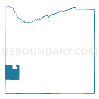
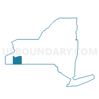
Voting District 290002, Cattaraugus County, New York
About
Outline

Summary
| Unique Area Identifier | 625727 |
| Name | Voting District 290002 |
| County | Cattaraugus County |
| State | New York |
| Area (square miles) | 33.03 |
| Land Area (square miles) | 32.81 |
| Water Area (square miles) | 0.21 |
| % of Land Area | 99.36 |
| % of Water Area | 0.64 |
| Latitude of the Internal Point | 42.13422650 |
| Longtitude of the Internal Point | -78.99939150 |
Maps

Graphs
Select a template below for downloading or customizing gragh for Voting District 290002, Cattaraugus County, New York


Neighbors
Neighoring Voting District (by Name) Neighboring Voting District on the Map
- Voting District 040001, Cattaraugus County, NY
- Voting District 050001, Cattaraugus County, NY
- Voting District 120001, Chautauqua County, NY
- Voting District 210001, Cattaraugus County, NY
- Voting District 210002, Chautauqua County, NY
- Voting District 290001, Cattaraugus County, NY
- Voting District 330001, Cattaraugus County, NY
Top 10 Neighboring County Subdivision (by Population) Neighboring County Subdivision on the Map
- Randolph town, Cattaraugus County, NY (2,602)
- Poland town, Chautauqua County, NY (2,356)
- Conewango town, Cattaraugus County, NY (1,857)
- Ellington town, Chautauqua County, NY (1,643)
- Napoli town, Cattaraugus County, NY (1,248)
- Coldspring town, Cattaraugus County, NY (663)
- South Valley town, Cattaraugus County, NY (264)
Top 10 Neighboring Place (by Population) Neighboring Place on the Map
Top 10 Neighboring Unified School District (by Population) Neighboring Unified School District on the Map
- Falconer Central School District, NY (7,329)
- Randolph Central School District, NY (6,597)
- Frewsburg Central School District, NY (4,904)